📢 Our demands!
[1] Wir fordern die zukünftige autofreie Umgestaltung der nördlichen Kiellinie zwischen dem Anleger Bellevue und dem Marinestützpunkt Wik!
[2] Als Übergangslösung bis zur Umgestaltung soll dieser Bereich, mindestens ab der Seebar/dem Seebad Düsternbrook Richtung Norden, jedes Jahr, ab dem Sommer 2026 von Anfang Juni bis Ende September, als Stadtlabor, Premiumroute und Aktionszone für alle Menschen geöffnet und für den Autoverkehr gesperrt werden.
[3] Ein Maßnahmen- und Verkehrskonzept für anliegende Wohngebiete und parallele Straßen (siehe unten).
💡 Why car-free?
The entire Kiellinie will be renovated and redesigned from the Schlossgarten/Seeburg to the Wik naval base. We are convinced that the northern Kiellinie must be upgraded for everyone, and this can only happen without the bull in the china shop, namely car traffic.
Safe routes for everyone and climate-resilient, environmentally friendly improvements instead of noisy, dangerous and smelly car traffic, which has a massive negative impact on the quality of life and leisure conditions in this area.
The northern Kiellinie is a jewel of the city of Kiel and offers many qualities that the remaining sections of the Kiellinie do not have or only have to a limited extent: it is surrounded by greenery, located directly on the waterfront and has plenty of usable space in between.
The future Kiellinie should be a space that creates opportunities and possibilities for activities and uses, rather than preventing them, as is currently the case.
The Kiellinie offers great potential as a local recreation area and space for exercise. It can be a place for strolling, playing, jogging, skating, cycling, meeting people, relaxing, recuperating and spending time. In addition, it is of great importance for tourism and for pedestrian and bicycle traffic, as it is the only level connection between the Wik and northern districts and the city centre and the rest of Kiel.
‘The car-free redesign makes it possible to completely rethink the Kiellinie Nord as a public space and fill this valuable space, which should be there primarily for people, with new life. The outdated, car-friendly design as a supposed expressway directly on the waterfront does not correspond to contemporary mobility and urban planning.’ (Julian Schüngel, OpenKiellinie initiative)
🗺️ What should the future Kiellinie look like?
The redesign as a promenade with a premium route for cyclists (and inline skaters, rollerbladers, scooters, etc.) set back from the landward side on parts of the current road, the creation of squares, seating areas, meeting places, playgrounds, green spaces, recreational areas and leisure facilities, as well as the creation of direct access to the water are essential components of the redesign plans.
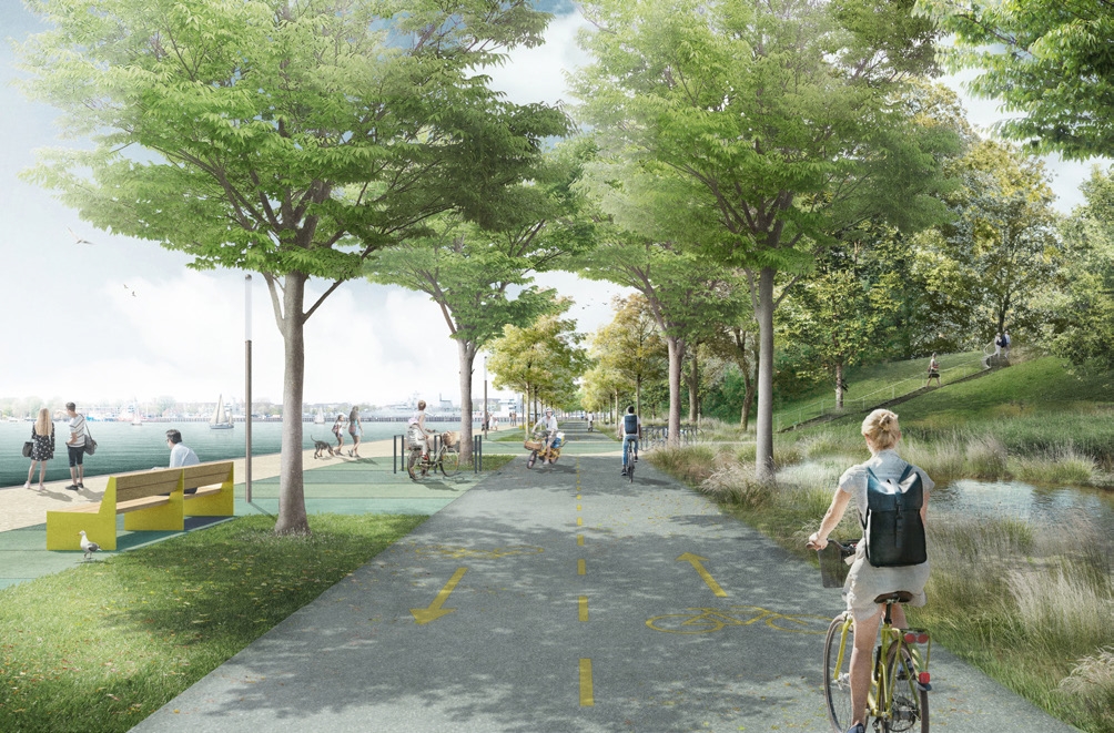
Fig. 1: Visualisation of the winning design in the urban development and open space planning competition for the redesign of the Kiellinie. Variant without car traffic on the northern Kiellinie. SStudio RW Berlin, Studio Wessendorf Berlin, Plancontrol Berlin. Source: LH Kiel.
We reject the idea of keeping the area open to car traffic, as well as half-hearted ‘compromise solutions’ such as a one-way traffic system. If car traffic remains in the Kiellinie, redevelopment and upgrading will not work – experts such as renowned urban and landscape planners and mobility experts are in complete agreement on this, also based on findings from the rest of the world.
‘And experiencing waves lapping, birds chirping and leaves rustling in the wind – that may be poetic, but for me it's a real motivation to fight for a car-free Kiellinie. In other words, the opportunity to experience nature and open spaces in the middle of the city.’ (Benjamin, OpenKiellinie initiative)
🚧 And what about car traffic?
The importance of the northern Kiellinie for car traffic has declined significantly in recent years and decades. The mobility transition in Kiel is in full swing: in addition to the general, documented decline in car traffic throughout the city, the number of motorists has fallen sharply, particularly on the Kiellinie.
The existence of many parallel alternative routes, which are particularly attractive for through traffic (e.g. the B76 as a high-performance corridor of the privileged basic network for car traffic), further demonstrates that this can no longer be considered a significant (district) road.
The annual growth in pedestrian and bicycle traffic, the expansion of the ferry and bus network, and the construction of the light rail system will continue to play a significant role in reducing the number of people who are dependent on cars as their sole form of transport.
📋 The car-free Kiellinie embedded in a mobility concept
To ensure that all residents of the neighbouring districts and nearby parallel streets also benefit and are not burdened by motorists who misuse their neighbourhood as shortcuts, a traffic concept with traffic circulation plans and upgrades to the existing road space is to be developed.
This applies in particular to a traffic concept for Düsternbrook, so that motorists in through traffic do not take shortcuts, for example through Niemannsweg.
In addition, it should be made clear from the bridges over the Kiel Canal that through traffic will be routed via the high-capacity B76 and that the Kiellinie (and the city centre area) will no longer be available for motorised through traffic. Counts are to be carried out on parallel roads such as Feldstraße and Holtenauer Straße, and measures (e.g. more secure crossing points, hazard- and noise-reducing speed limits) are to be implemented to counteract possible nuisances caused by the initial shift in car traffic.
The effect of ‘traffic evaporation’ can be seen in redesigns and road closures around the world: car traffic is not simply shifting one-to-one to alternative routes, but is reducing, ‘evaporating’ so to speak, partly because redesigns are enabling people to get around actively, healthily, in a city-friendly and future-oriented way on foot, by bike and by public transport.
📢 Our specific demands!
[1] Wir fordern von der Ratsversammlung der Stadt Kiel die zukünftige autofreie Umgestaltung der nördlichen Kiellinie zwischen dem Anleger Bellevue und dem Marinestützpunkt Wik!
[2] Als Übergangslösung bis zur Umgestaltung soll dieser Bereich, mindestens ab der Seebar/dem Seebad Düsternbrook Richtung Norden, jedes Jahr, ab dem Sommer 2026 von Anfang Juni bis Ende September, als Stadtlabor, Premiumroute und Aktionszone für alle Menschen geöffnet und für den Autoverkehr gesperrt werden.
[3] Ein Maßnahmen- und Verkehrskonzept für anliegende Wohngebiete und parallele Straßen.
Share the petition and let your friends and family know!
Let's work together to make our city a better place!
Supporting initiatives, associations and movements:
- OpenKiellinie
- VCD Ortsgruppe Kiel
- Fridays for Future Kiel
- NABU Kiel
- Junger Rat Kiel
- PSC CAU – Progressiv Studentischer Campus CAU Kiel
- Critical Mass Kiel
- (more will be added soon)
Supportive initiatives, associations and movements:
Mail: openkiellinie[at]web.de
Instagram: https://www.instagram.com/openkiellinie
Mastodon: https://norden.social/@OpenKiellinie
Telegram-Info-Channel: https://t.me/OpenKiellinie
Image credits
Figure 1: Visualisation of the Kiellinie. URL: https://www.kiel.de/de/kiel_zukunft/kiel_plant_baut/_wettbewerb_kiellinie/kiel_kiellinie_wettbewerbsarbeit_1013.php
Links: