Here you will find a list of frequently asked questions about OpenKiellinie, the redesign of the Kiellinie and the petition ‘Car-free Kiellinie now!’.
If you have a question that isn't listed here, feel free to contact us via email at openkiellinie [at] web.de, Instagram, or Mastodon!
About us as the OpenKiellinie initiative
Who is behind the OpenKiellinie team?
The OpenKiellinie team consists of residents from the surrounding neighborhoods, students, people involved in urban development, mobility, climate and environmental protection, and people who simply love the Kiellinie and want to improve it.
Are you getting paid for this?
We are not paid for our commitment. We pay all costs incurred from our own pockets (e.g. for banners, music, chalk, soap bubbles, stickers, etc.). However, there is a small donation box at the information stand near the pavilions during OpenKiellinie to help offset this financial burden.
Is the OpenKiellinie a project of the city of Kiel?
No. We, the OpenKiellinie initiative, are not a project of the City of Kiel and have no direct connection to it or to the political parties in the Kiel City Council.
I want to get actively involved!
We welcome anyone who wants to lend a hand and support us! Just get in touch with us by email (openkiellinie [at] web.de), Instagram or Mastodon! ... Or simply drop by the next OpenKiellinie on the first Sunday of the month and talk to us =)
How else can I support you?
Spread the word! Tell people about OpenKiellinie, share the petition for a car-free Kiellinie. Raise your voice when people talk nonsense about the initiative, the assembly or the petition! Let's stand up together for a better city!
Redesigning the Kiellinie
Why is the Kiellinie being redesigned?
The Kiellinie is old and showing its age. In some places, the sheet pile walls need extensive renovation. Whereas strolling used to be the main activity here, today there are many more uses and demands on this space.
The way the Kiellinie is currently designed, it does not meet today's requirements, let alone a future-oriented, improved design. In addition, the Kiellinie from the palace gardens to the naval base is characterized by its fragmented and disjointed nature. In some places, there are many attractions (and large crowds), while in others, the quality of the experience is poor and people tend to use these sections to pass through rather than linger. There is great potential for improvement.
How will the Kiellinie be redesigned?
The redesign of the Kiellinie is intended to provide more opportunities for use and more direct access to the water, as well as ensuring that the Kiellinie can be experienced and used as a continuous waterfront promenade. In addition to the extensive urban planning and open space planning competition process, the residents of Kiel (and all interested parties) were also able to get involved and share their wishes, ideas, criticism, and suggestions with the planners.
Where can I find out about the current status?
At https://www.kiel.de/de/kiel_zukunft/kiel_plant_baut/kiellinie.php you will find all documents, information, and the current planning status for the redesign of the Kiellinie.
How can I get involved? Is there any citizen participation?
Citizen participation in the redesign of the Kiellinie has been ongoing for a long time. Over 1,000 people took part in the largest events in November 2024! In addition, there have already been information events and a separate participation format for children and young people. Ideas, wishes, and suggestions can be submitted to the city planning office at any time.
A separate participation process will be held to determine whether the Kiellinie Nord should be car-free or continue to be open to traffic. All information on the redesign and participation can be found on the project page of the state capital Kiel:www.kiel.de/de/kiel_zukunft/kiel_plant_baut/kiellinie.php
In addition, signing our petition for a car-free northern Kiellinie is also worthwhile! This is another way to get involved and set an example for good design!
OpenKiellinie „Event“
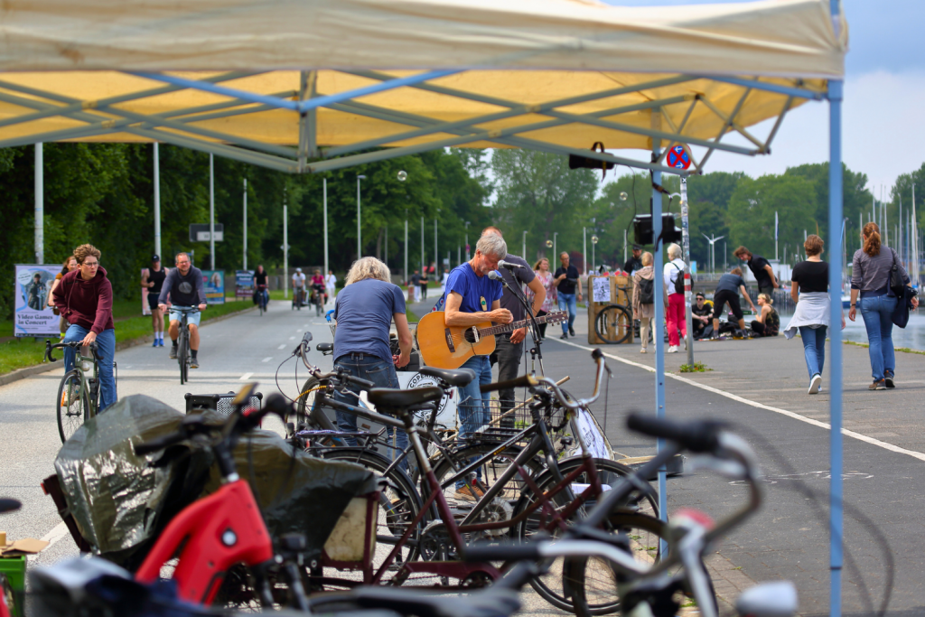
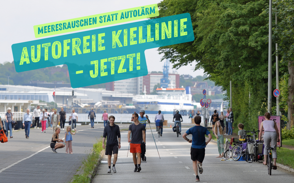
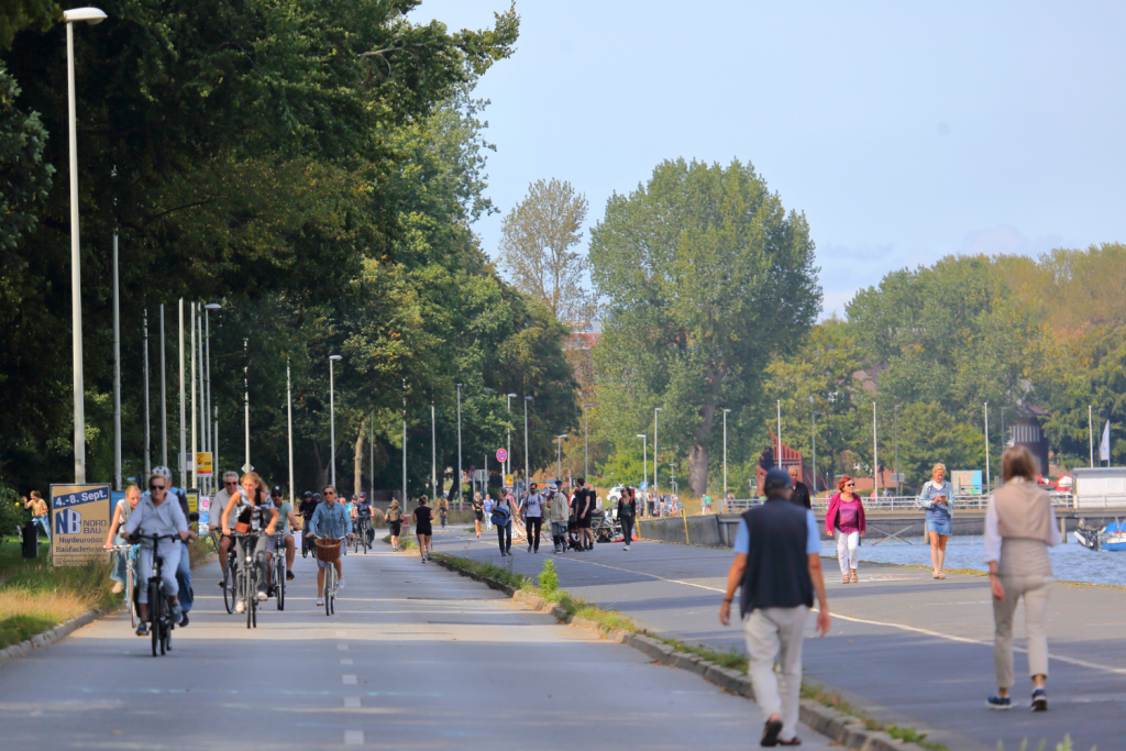
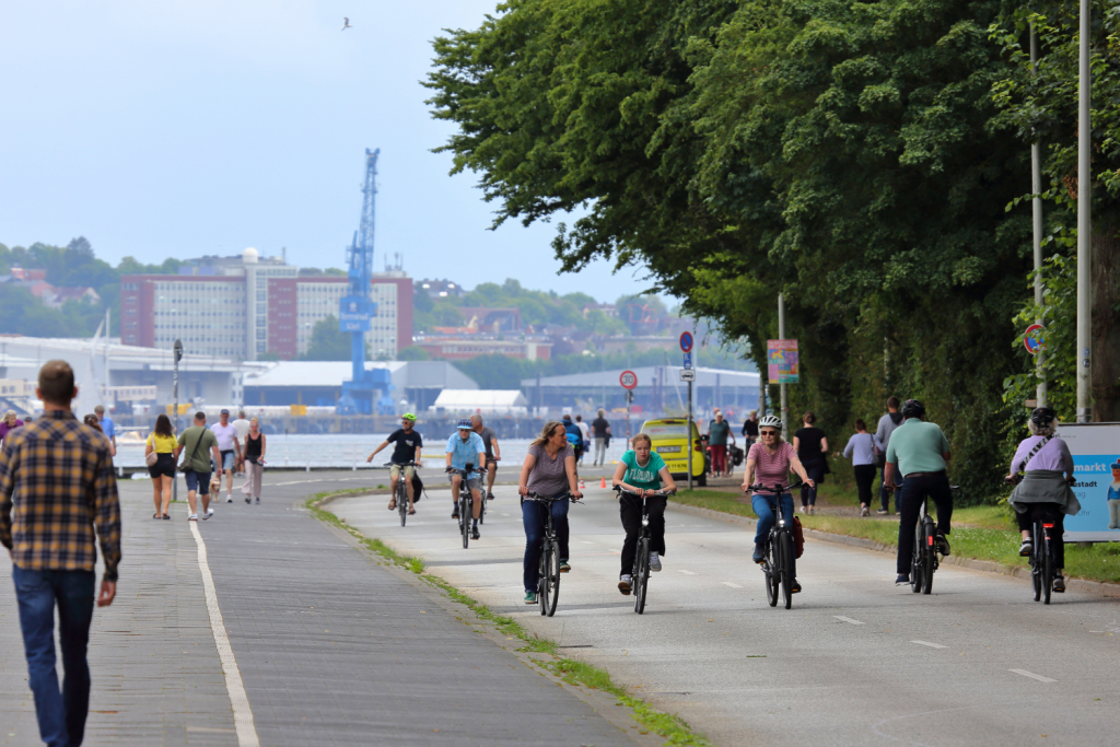
What exactly is the ‘OpenKiellinie’?
The OpenKiellinie is a demonstration, or more precisely a "Kundgebung", demonstrating in favour of making the northern Kiellinie car-free. Visitors are given the opportunity to reclaim this area for a few hours each month, fill it with life and enjoy the benefits of a car-free Kiellinie.
When does OpenKiellinie take place?
We plan to register a gathering for every first Sunday of the month from June to October 2025 so that OpenKiellinie can take place from 10 a.m. to 6 p.m. The first two OpenKiellinie events took place in late summer 2024. You can find more information on the website under ‘OpenKiellinie “Event”’.
What is permitted on the OpenKiellinie – and what is not?
The basic rule is: look out for each other, behave safely and cautiously. Take space for actions and activities – but leave room for others (in particular, at least one side of the road for flowing non-motorized traffic). If you have any questions, problems, or uncertainties, please contact the organization team at the pavilions in Hirschfeldpark. These are located in the middle of the OpenKiellinie.
The instructions of the head of the demonstration must be followed. Persons who fail to comply with these instructions may be excluded from the demonstration.
No-gos: Driving motor vehicles, i.e. cars, trucks, motorcycles, etc., in the area. The road is closed to motor vehicle traffic by traffic signs and barriers.
Furthermore, we do not accept any behavior that is discriminatory, racist, homophobic, or otherwise hostile toward others.
Is the Seebar and the Düsternbrook public bath accessible and open?
The Seebar and the Düsternbrook public bath are fully accessible and open.
Drivers coming from the south can drive unhindered from the Bellevue pier intersection to Seebar/Seebad.
The disabled parking spaces directly in front of the seaside resort/seebar are also accessible at all times.
The disabled parking spaces directly in front of the Seebad/Seebar are also accessible at all times. Visitors to the Seebad/Seebar on foot, by bicycle, etc. can reach them as usual from all directions.
‘The OpenKiellinie excludes motorists!’
No, not at all! Drivers are welcome to visit OpenKiellinie at any time – they just need to park their vehicles outside the area.
“But then I won't be able to drive along the Kiellinie and look out over the fjord anymore!”
Not at ll! Drivers can still drive freely in the Berthold-Beitz-Ufer area and the northern Kiellinie from Koesteralle onwards and enjoy the view of the fjord. Just as they can 24/7 throughout the rest of the year.
We naturally recommend that drivers concentrate on the road rather than letting their eyes wander over the landscape or simply park your car and visit the Kiellinie, which is open to the public.
Petition Autofreie Kiellinie – Allgemein
Where can I sign the petition?
The online petition can be found on the change.org platform. Via the link https://www.change.org/AutofreieKiellinie it can be accessed and signed. The link can be clicked on and accessed at the top right of this page next to the icons, as well as at the bottom of the page and on the “Petition” subpage.
Is there also an ‘analogue’ petition list somewhere?
Unfortunately, there is no “analog” petition list.
However, Change.org is a well-known and established petition website.
What is the goal of the petition?
We demand (1) the future car-free redesign of the northern Kiellinie.
(2) As a temporary solution, the area from shall be open to all people and closed to motor vehicle traffic from June to September (starting in summer 2026), from Seebar/Seebad northward.
(3) Integration into a traffic and action plan for adjacent residential areas (against rat-running). You can find more information at https://www.change.org/AutofreieKiellinie.
Who is the petition addressed to?
The petition is addressed to the democratic parties in local politics and to the council assembly of the state capital Kiel, which will make the final decision on the options (car-burdened or car-free).
Which other organisations and initiatives support the petition?
So far, the petition has been supported by us, the local Kiel committee of the VCD, NABU Kiel, the Junger Rat Kiel (The Young Council Kiel), Fridays for Future Kiel, PSC CAU, and the Critical Mass Kiel movement.
![]()
We as an association/initiative/company etc. would also like to become supporters!
We are delighted to have the support of all these organizations, initiatives, associations, and companies!
Just send an email to openkiellinie [at] web.de! Feel free to include a logo so we can add you to our list of supporters!
I want my club/initiative/company to become a supporter!
Ask your management, discuss it at a meeting, and let us know if the decision is positive!
Just send an email to openkiellinie [at] web.de! Feel free to include a logo so we can add you to our list of supporters!
How can I support the petition?
Share the link to the petition > https://www.change.org/AutofreieKiellinie < with your family, friends, at work, in groups and clubs! Talk about it and spread the word about the petition! Thank you! =)
Petition Autofreie Kiellinie – Inhaltlich
How many cars drive across the Kiellinie Nord every day?
The importance of the northern Kiellinie for car traffic has declined enormously in recent decades and years. Today, the number of cars is around 4,500 per working day.
Outdated data from the year 2000 showed figures of 7,000 cars per working day, but these are no longer accurate.
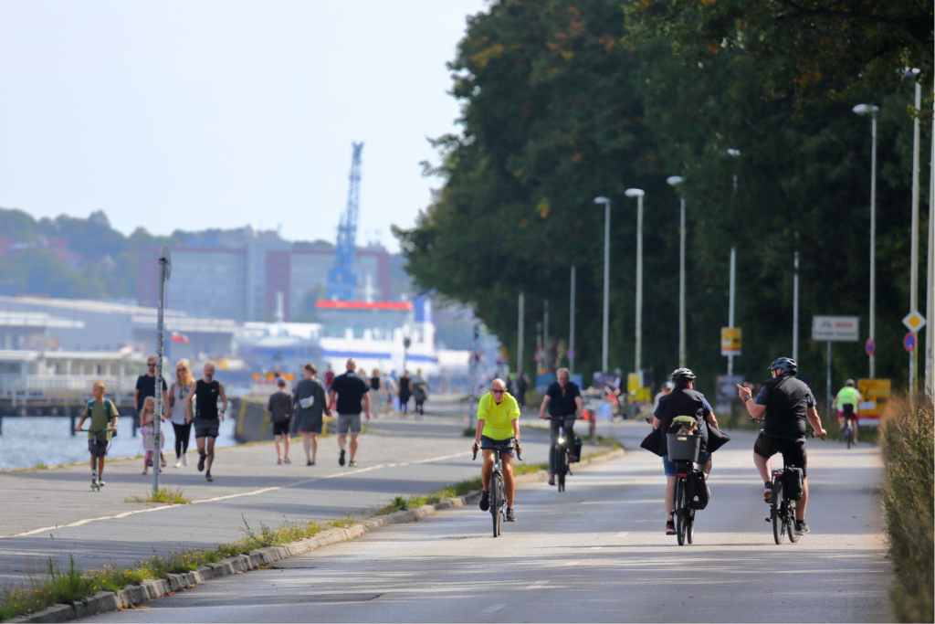
What significance does the northern Kiellinie have for pedestrian and bicycle traffic?
It is often claimed that the northern Kiellinie has no significance for bicycle traffic—or only for recreational use. Critics of the car-free Kiellinie often ignore the fact that this area is part of Veloroute 1, part of the Baltic Sea Cycle Route, and one of the most frequently used connections for bicycle traffic. The Kiellinie Nord is the only connection between Wik and the northern districts of Kiel and the city center that does not have any significant inclines. It is therefore particularly important for the mobility of less experienced, disabled, younger, and older people who use bicycles.
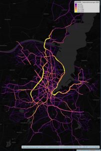
Abb.: Heatmap Stadtradeln. Quelle: LH Kiel Präsentation, Seite 12.
The importance of the northern Kiellinie for pedestrian traffic should not be underestimated either. It serves as an everyday route and a route to school. It also plays an important role (albeit limited by car traffic) for tourism and local recreation and is the link between the fjord slope (Düsternbrooker Gehölz, Diederichsenpark/Forstbaumschule, Orchideenwiese) and the fjord.
Unfortunately, this green/blue connection is limited, as road traffic cuts through these areas. This makes it almost impossible for older people in particular, who are no longer able to walk well and use walkers or wheelchairs, to cross the street.
Will car traffic shift 1:1 to Feldstraße if the road is closed?
No, car traffic will not shift 1:1 to Feldstraße. Such outdated calculations have been proven wrong in traffic science.
Unfortunately, the City of Kiel also uses this purely quantitative engineering calculation method (as of 2020, Präsentation zur Kiellinien-Umgestaltung, LH Kiel), which disregards human mobility and transportation behavior.
Several aspects come into play here:
(1) Affected sections of a road that are closed usually only represent a part of a car journey. The entire car journey is longer, and other routes, which do not necessarily have to be directly adjacent, become more attractive for covering the entire distance. The privileged road network for car traffic (county roads, state roads, federal highways, motorways) is also designed for this purpose. “Why drive ‘below’ through the city, where the Kiellinie Nord is now closed, when it's much easier to take the B76?”
(2) Induced traffic: If infrastructure is built, users will come. The same applies, as can be seen worldwide, to the opposite: if infrastructure is removed, the number of users will also decrease. If a city removes sidewalks, there will be fewer pedestrians. If a city removes bike lanes, fewer people will use bicycles. If a city reduces its public transport network, fewer people will travel by bus. The same applies to car traffic: if a city reduces the number of lanes for car traffic, fewer people will use their cars. This is true for all modes of transport; car traffic is no exception. Incidentally, the principle of induced traffic is the central finding of 100 years of transport science.
(3) Attractive alternatives for getting around: Closing roads to car traffic increases the appeal of other modes of transportation. Buses no longer get stuck in traffic jams, people on bicycles are no longer overtaken, cut off, and honked at by motorists (as happens on the Kiellinie), people on foot can talk without noise, and streets become more pleasant and safer with less car traffic. This means that these streets are used more because their quality is improved, making connections more attractive. This is the same reason why highways are built—better infrastructure, more users.
Während 2020 (mit Daten von 2015, 2018, 2019) von rund 7.000 PKW/Werktag (DTVw) auf der Kiellinie gerechnet wurde, liegt die Höhe der letzten Erhebungen der PKW-Belastung/Werktag bei rund 4.500.
Will there be increased congestion in the short term due to traffic diversion?
Yes, any change in transport networks initially causes things to “stutter and jerk” a little at first. People first have to find new routes, habits have to be adjusted, and people have to discover new modes of transport that allow them to reach their destination in a more relaxed and efficient manner. This initial adjustment phase can last two to three weeks, sometimes more, sometimes less, and then often disappears as quickly as the change occurred in the first place.
Good communication and traffic management measures, which are introduced before changes to road accessibility take effect, further reduce this initial adjustment phase.
However, as the importance of the northern Kiellinie for car traffic is declining year by year and the number of cars counted is steadily decreasing, it can be assumed that closing the northern Kiellinie to car traffic (and opening it to people) will mean a much less drastic change than was expected a few years ago.
What about the residents of the surrounding and parallel streets?
In many intensive and constructive discussions with residents from neighboring districts and streets such as Wik, Düsternbrooks, Holtenauer, and Feldstraße, we have gained a key insight: The vast majority think the idea of a car-free Kiellinie, the redesign as a promenade, better access to the water, improvements for pedestrians and cyclists, and more seating and play areas are great.
What critics agree on is the existing and feared car traffic in their street and neighborhood.
We are convinced, and this is why it is also part of our petition, that everyone, including the residents of the streets and neighborhoods surrounding the Kiellinie, should benefit and that improvements should be developed on the basis of a concept of measures.
To ensure that all residents of the neighbouring districts also benefit and are not burdened by motorists who misuse their neighbourhood as shortcuts, a traffic concept with traffic circulation plans and upgrades to the existing road space is to be developed.
This applies in particular to a traffic concept for Düsternbrook, so that motorists in through traffic do not take shortcuts, for example through Niemannsweg.
In addition, it should be made clear from the bridges over the Kiel Canal that through traffic will be routed via the high-capacity B76 and that the Kiellinie (and the city center area and, for example, Feldstraße) will no longer be available for motorized through traffic. Counts are to be carried out on parallel roads such as Feldstraße and Holtenauer Straße, and measures (e.g., more secure crossing options, hazard- and noise-reducing speed limits) are to be implemented to counteract possible pollution caused by initially diverted car traffic.
The effect of “traffic evaporation” can be seen in redesigns and road closures around the world: Car traffic is not simply shifting 1:1 to alternative routes, but is reducing, “evaporating” so to speak, partly because redesigns are enabling people to get around actively, healthily, in a city-friendly and future-oriented way on foot, by bike and by public transport.
What will happen to the Düsternbrook public bath and the Seebar when the Kiellinie Nord is closed?
Critics argue that the Seebar and the Seebadeanstalt would then be located in the middle of a car-free zone and could no longer be supplied, for example.
That is not true. Deliveries and disabled parking spaces in front of the Seebar/Seebad will continue to be guaranteed and accessible. This is part of the plans and has been planned from the outset.
The marina will also remain accessible via the Koesterallee car park and, as usual, via the Kiellinie for launching boats.
Critics claim: “Closing the northern Kiellinie will lead to higher CO² emissions.”
No, closing the northern Kiellinie does not necessarily lead to higher CO² emissions. As already explained, closing roads leads to more people walking, cycling, and using public transportation due to the shift to other modes of transport and changes in route selection. Alternative routes, especially for through traffic that previously used the Kiellinie only as a quick shortcut from A to B, can even result in fewer toxins being emitted into the air.
Kritiker*innen behaupten: „Die Sperrung der nördlichen Kiellinie kommt es zu Stau und zu mehr Luftbelastung durch Feinstaub etc.“
No, closing the northern Kiellinie will not necessarily lead to more particulate matter and air pollution caused by traffic jams.
For example, the State Agency for the Environment and Measurements Baden-Württemberg says:
The State Agency for Environment and Measurements (LUBW) provided clarification upon request. (...): “Fine dust is caused partly by turbulence and partly by abrasion from tires and brakes. When traffic is at a standstill, there is less turbulence and abrasion, which means that high levels are not caused by traffic jams,” says Wilfried Weiß, head of the Air Quality Department at LUBW. According to Weiß, the concentration is unlikely to increase during a traffic jam.
(…)
Even for nitrogen dioxide, a pollutant produced by combustion, the level is lower in traffic jams or when traffic is flowing smoothly than during constant stopping and starting. Idling produces a lower concentration than stop-and-go driving.
(…)
The values indicate that the air pollution problems can only be brought under control by significantly reducing traffic, according to the German Association for the Environment and Nature Conservation (BUND). (Source: StZ)
Why not simply widen the northern Kiellinie?
As already explained in detail in the previous question, upgrading the Kiellinie, developing it as an extension of the promenade with a high quality of stay, and improving conditions for pedestrians and cyclists (and everyone else) cannot succeed if the “ bull in a china shop,” i.e., through traffic, continues to exist.
The heavyweight wall that secures the promenade in this area was built in 1910 and, apart from the usual maintenance requirements such as filling joints, is in good condition. In fact, it is in such good condition that installing a sheet pile wall would not be economically viable.
... and it doesn't solve the problem.
Critics claim: “If traffic is diverted away from the Kiellinie, conditions will deteriorate everywhere!”
Critics claim that closing the Kiellinie will make the city center less attractive and put pressure on restaurants and retailers. On the one hand, this seems like a far-fetched talking point aimed at stirring up emotional, world-ending fears. On the other hand, this argument is based on the misconception that people who use cars do not choose the most efficient route for them (e.g., via district, state, federal roads, and highways), but instead drive straight to or just before a roadblock and only then ask themselves how to get ahead. Neither people nor GPS route planners work that way.
Furthermore, it is evident in Kiel that there is an ever-increasing shift from cars to efficient, sustainable, and city-friendly modes of transportation.
“Should everyone now travel on foot, by bike, bus, and tram?!”
Every person walking, cycling, taking the bus, or riding the tram is one more free parking space, one less car in rush hour traffic, one less car at the next red light on the way home.
People who use cars should actually be the biggest advocates for more people using modes of transportation other than cars. However, this will only work if these modes of transportation are promoted and the infrastructure is improved.
- Example: A bus carrying 80 passengers is very space-efficient (example: Kiel, bus length: 18.75 m, max. 116 passengers). If these 80 passengers were to travel by car, this would create an average traffic jam* (known as a “congestion”) of 511 meters. This represents an area consumption of around 20 m compared to 511 m for the same number of people. In the future, each light rail vehicle will have a maximum capacity of 325 or 375 passengers – this corresponds to a line of cars* up to 2.380 kilometers long, compared to the length of a light rail vehicle of 45 or 54 meters. [*Calculation: average occupancy rate of 1.1 people/car, 5 meters vehicle length, 2 meters distance between vehicles]
Of course, this does not mean that everyone should suddenly start using modes of transport other than cars – but the more people who do so, the better it is for all road users, especially those who use cars.
Critics claim: “No permanently attractive space can be created on the northern Kiellinie, so closing it off to motor-traffic would not be justified.”
This statement initially causes irritated reflection, but it helps to rephrase the critics' statement as follows: “The northern Kiellinie is currently unattractive (in their eyes) and will therefore remain so forever in the future.”
Critics should also be aware, since at least 2020, that the City of Kiel is planning many uses and improvements for the Kiellinie Nord throughout the year, as this is stated just a few slides before the document that critics like to link to in order to argue against the Kiellinie. (See: Präsentation zur Kiellinien-Umgestaltung, LH Kiel, S. 33 ff.)
In our opinion, this narrow and one-sided perspective of the criticism falls short. The accusation is that there are no offers or usage concepts for the Kiellinie Nord outside of the summer season. This is not true. The plans for the Kiellinie Nord include many attractive uses and activities for people to enjoy throughout all seasons.
The assertion that a space is not beautiful in “bad weather” or “in winter” can, of course, be applied to any other place in Kiel: Schrevenpark in gray-brown-rainy winter: Nah. The southern Kiellinie promenade in autumnal crappy weather: Also not very attractive. The pedestrian zone in the winter months: lively, but not pretty either.
Just because this is the case, critics would never dream of demanding that cars be allowed to drive in and through Schrevenpark, on the current Kiellinie promenade, or through the pedestrian zone. But they do this with the northern Kiellinie. That is not consistent.
Reality also shows that the northern pier is well visited in every season.
(Of course, there are times when there are no people to be seen there, but there are also times when there are no cars driving there either).
Critics claim: “When the northern Kiellinie is closed to car-traffic for events such as OpenKiellinie or other events and demonstrations, it becomes a ‘yawning void’.”
This claim contradicts the actual, counted visitor numbers (see Unterseite OpenKiellinie (Seitenende)). Of course, there are also moments when there is little going on, for example after a rain front has passed. But here we must also be honest and acknowledge that when a rain front passes, the pedestrian zone and the southern promenade also appear more deserted.
No one would demand that car traffic should be allowed in the pedestrian zone or on the southern Kiellinie promenade just because it rains in Kiel from time to time.
Critics claim: “The infrastructure and quality for pedestrian and bicycle traffic do not need to be improved on the northern Kiellinie because there is hardly any pedestrian or bicycle traffic there anyway.”
This claim is refuted by actual traffic figures. The northern Kiellinie has a high volume of pedestrian traffic and is one of the central connections for bicycle traffic in Kiel.
Even assuming that this assertion were true (which it is not), a comparison helps here too: one does not refute the necessity of a bridge over a river by counting how many people are currently swimming across the river to get to the other side.
Wouldn't a compromise be a possible solution?
Various ideas were put forward by advocates of car traffic on the Kiellinie as supposed compromises. These included time- and day-dependent restrictions on pedestrian and bicycle traffic quality so that car traffic could travel unhindered along the northern Kiellinie.
Another idea is to introduce a one-way system for car traffic so that car through traffic can continue to use the Kiellinie.
All proposed “compromises” have one problem: if car traffic remains in the Kiellinie, redevelopment and upgrading will not work – experts such as renowned urban and landscape planners and mobility experts are in complete agreement on this, also based on findings from the rest of the world.
With these “compromises,” car traffic remains the elephant in the room, perpetuating problems such as noise, exhaust fumes, and traffic safety. This becomes particularly clear when one imagines what car traffic would be like in other parts of Kiel (even if only as a one-way street): on the promenade, in the pedestrian zone, on the MFG5 site, through the Projensdorf woods, etc.
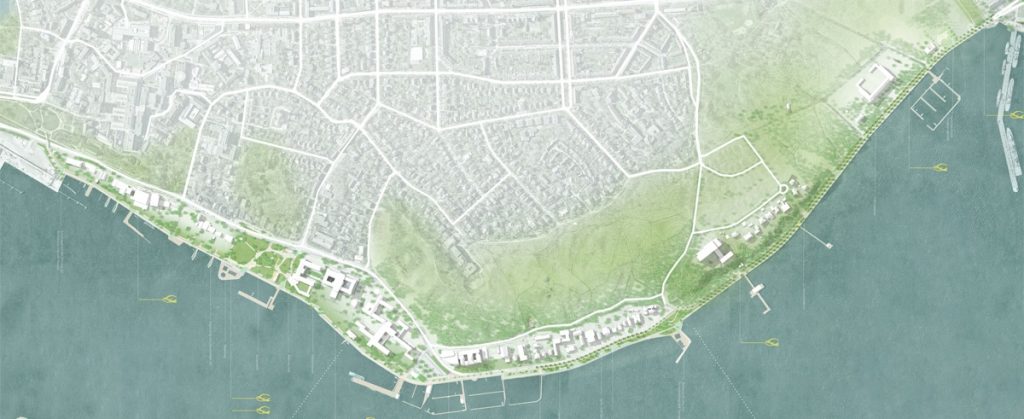
Source of overview plan: State capital Kiel. Competition entry 1013 1. Price. Studio RW Berlin, Studio Wessendorf Berlin. URL: https://www.kiel.de/de/kiel_zukunft/kiel_plant_baut/_wettbewerb_kiellinie/kiel_kiellinie_wettbewerbsarbeit_1013.php (Date: 30.07.2025)